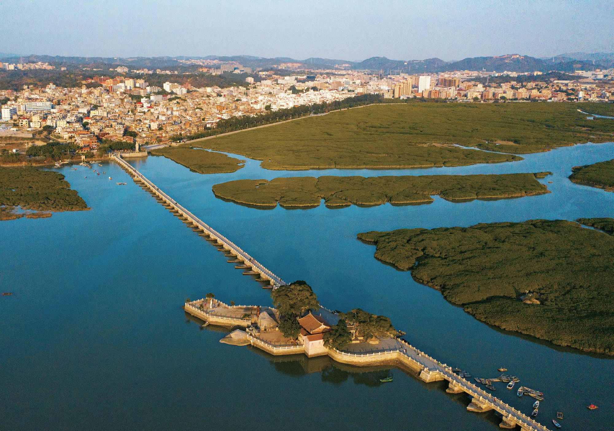
Luoyang Bridge crossing the tidal estuary near Quanzhou

Historic bridge · Northeast Quanzhou

Luoyang Bridge

A thousand-year-old tidal crossing that makes the infrastructure behind Quanzhou's world port unusually easy to see.

Chinese map name
洛阳桥 Luoyang Bridge
Role in the port
Overland transport and estuary engineering
Historic period
Built 1053-1059, Northern Song
Time on site
Allow 1.5-2 hours on site

洛阳桥

Why would a maritime trading city need a bridge this ambitious?

Luoyang Bridge, historically called Wan'an Bridge, crosses the tidal Luoyang River northeast of Quanzhou's old city. It was built between 1053 and 1059, when Quanzhou's overseas trade was expanding and the city needed more dependable land connections to the north. The bridge replaced a dangerous ferry crossing and linked the port more firmly to routes towards Fuzhou and the wider coast.

Its importance is therefore larger than its age or appearance. A port does not work through ships alone. Cargo, officials, merchants, letters and travellers must also move across rivers and through a hinterland. Luoyang Bridge is one of the clearest places to understand that Quanzhou's maritime success depended on public works, administration and engineering on land.

The bridge seen today has been repaired many times over nine centuries. That layered history is part of the site: it remained useful, weathered earthquakes and storms, and was repeatedly adapted rather than preserved as an untouched monument.
On site

What to look for

The site becomes more legible when you know which physical clues carry its larger story.

Start with the whole setting, then move closer. Architecture, archaeology and landscape often reveal different parts of the same argument.

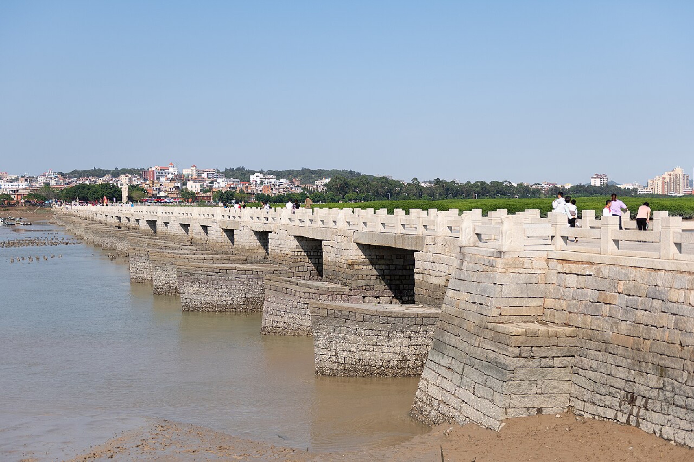
The long, low stone deck and tidal setting of Luoyang Bridge

01

A bridge shaped by tides

The profile is long and low rather than dominated by high arches. Read it as a structure built across a broad tidal channel, where water level and current controlled construction and daily movement.

02

Boat-shaped stone piers

The pointed piers divide the current and reduce pressure on the structure. From the side, they make the bridge's response to moving water much easier to understand.

03

Raft foundations and oyster beds

Builders spread large stones across the riverbed to form a stable base, then used oyster growth to help bind stones around the foundations. The method joined local ecological knowledge to heavy stone construction.

04

Inscriptions, shrines and memory

Pavilions, stone figures, inscriptions and the memorial to official Cai Xiang show that the bridge was also a civic achievement remembered through writing, worship and local stories.

Luoyang Bridge crossing the tidal estuary near Quanzhou

Read the port system

The bridge is the port story before the shoreline

UNESCO describes Quanzhou as an integrated system of production, transport, administration, markets and diverse communities. Luoyang Bridge belongs to the transport layer. It helped extend the city's reach beyond the walls and made the movement of people and goods more reliable at a difficult estuary crossing.

This is why the site works especially well after a day in the historic centre. Temples and mosques show who lived in the port; the bridge shows one of the physical systems that allowed the port to function. Seen together, they turn a collection of monuments into an urban and regional network.

See all 22 component sites

Research lens

What scholarship adds to the visit

Research makes Luoyang Bridge more than an engineering ‘first’: it was a durable intervention in the land routes feeding a maritime city.

01

Infrastructure widened the port's catchment

Pearson, Li and Li place the bridge within the routes linking Quanzhou to its hinterland. Replacing a difficult ferry made movement of people and goods more dependable north of the city.

Read the source

Richard Pearson, Li Min and Li Guo, ‘Quanzhou Archaeology: A Brief Review’ (2002)

02

Engineering responded to an estuary ecosystem

The nomination highlights raft foundations, pointed piers and the use of oyster growth around the stonework. These features join heavy construction with close knowledge of tides and riverbed conditions.

Read the source

Quanzhou World Heritage nomination dossier (2020)

03

Continuity includes repair

ICOMOS evaluates authenticity across repeated interventions rather than assuming an untouched medieval object. The bridge's continued use and repair are part of its history, but individual elements belong to different dates.

Read the source

ICOMOS evaluation of the revised Quanzhou nomination (2021)

Plan the visit

Make the time on site count

These are planning decisions, not fixed opening-hour claims. Recheck access and transport shortly before travel.

01

Go for the landscape, not a quick photo

Walk far enough onto the bridge to see the tidal flats, stone deck and piers as one system. The setting changes with tide, light and weather, so the site rewards a slower crossing.

02

Use the Chinese map name

Save 洛阳桥 and the older name 万安桥. Map pins can refer to the bridge, nearby old street or different entrances; show the exact pin to a driver.

03

Treat it as a separate outing

Road time from the historic centre varies with traffic. A taxi or ride-hailing car is usually simpler than trying to insert the bridge between tightly timed downtown stops.

04

Check conditions shortly before travel

Rain, strong wind, maintenance or crowd controls can change the experience. Confirm current access locally and wear shoes suitable for an exposed stone surface.

Connect the place

Build a north-and-estuary half day

For a focused visit, make Luoyang Bridge the main destination and leave time for the surrounding river landscape. For a fuller day, connect it with the Statue of Lao Tze, the Islamic Tombs or Quanzhou Maritime Museum rather than crossing the city again for Jinjiang sites.